 The Garmin brand has long taken a strong position in the GPS navigation market, so it’s impossible to review all garmin navigators in one article. However, we will try to consider the main advantages and disadvantages of these devices.
For about 30 years, Garmin has been a leader in its field, manufacturing and distributing unique devices with GPS technology. The range of application of the manufactured navigators is quite large, for example:
- navigators for cars;
- navigators for motorcycles and ATVs;
- cycling;
- for tourists, hunting and fishing;
- hand held;
- to track dogs;
- marine.
All Garmin navigators are tailored to specific consumer groups. Managing Garmin GPS devices does not require special skills, so anyone can figure out their functionality. Navigators are characterized by convenience and ease of use, compactness, intuitive interface, high quality workmanship and a long guarantee of continuous operation.
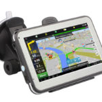
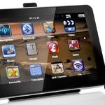
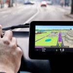
Car navigators
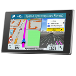
The first navigators were used by the military to navigate in dense forests. However, moving around the stone jungle can also cause a lot of difficulties for an inexperienced driver. And experienced motorists will not give up useful tips regarding the presence of traffic jams or choosing the best route. Modern Garmin navigators have all the necessary resources to provide the driver with up-to-date information on the state of traffic on the roads. Consider Garmin car devices using the DriveLuxe 50LMT as an example.
Main settings:
- five inch touch screen;
- metal housing with magnetic mount;
- accumulator battery;
- voice control.
Among the features of this device can be noted:
- Driver warning of traffic situation:
- about DPS cameras;
- about speed bumps;
- about traffic jams;
- about the beginning of school zones;
- sections of the road with a high risk of wildlife;
- about sharp turns, etc.
However, you should periodically download the latest data from the Internet. Garmin.ru is one of the main addresses where you can update the garmin navigator.
- Synchronization with a smartphone via Bluetooth allows, without taking off the steering wheel, to observe all the necessary information about calls, SMS and other notifications on the navigator screen and to answer calls using voice control.
- The free Link8 application allows you to place weather data on the screen, which will be updated in real time thanks to the mobile traffic of the smartphone.
- A set of navigation maps that can be updated for free throughout the life of the device.
- Real-time information about traffic jams and traffic jams in real time using TMS technology, which works without the participation of mobile Internet.
- Display visual three-dimensional images on complex sections of the road and during the choice of lane.
- The DriveLuxe system allows you to navigate in space with the help of famous attractions and prominent buildings, rather than turns.
- Ability to connect a wireless rear view camera or baby monitor.
Among the disadvantages of this device, a high cost can be distinguished, however, the set of functions described above fully justifies it.
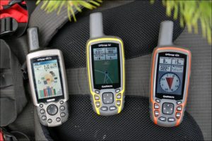
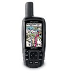
Travel Navigators
The scope of use of GPS devices is increasing every day, so it is not surprising that it is tourists who increasingly began to acquire portable navigators for orientation on the ground. After all, now there is no need to take with you a lot of useful, but now no longer needed devices, for example, compasses, altimeters and maps. With just one small device, you can fully enjoy the beauties of our nature.
You may have a question about why to purchase a tourist navigator in the presence of a car.But the big drawback of the latter is a very weak battery, which can ensure the operation of the device only for several hours. In comparison, devices for tourists work more than a day. Also, car navigators cannot boast of high protective properties. The thicket does not differ in the comfortable conditions of the passenger compartment. There is a high probability of damage to an unprotected device by moisture, dust, etc.
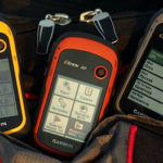
Garmin Travelers
Every Garmin travel device is characterized by the following features:
- joint use of the GPS system and the GLONASS system, which significantly reduces the time to determine the location;
- the case is protected from moisture, dust, shock;
- built-in compass;
- a barometer that can be used to determine the height and probability of precipitation;
- the necessary cards can always be additionally loaded if they are not provided by the basic package;
- even in bright sunlight, you can easily read information from the screen;
- steady work even in dense clouds or in ravines.
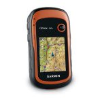
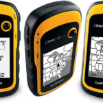
The Garmin etrex 30 navigator was very popular among outdoor enthusiasts. Among the features of this device are:
- moisture proof housing;
- not afraid of blows;
- The 3-axis compass indicates the right direction, even if held incorrectly;
- if necessary, the device can be used in a car, motorcycle, bicycle, ATV or boat, for which it is necessary to purchase a suitable mount;
- the ability to install additional maps, including bitmaps;
- data exchange with other devices wirelessly;
- the ability to connect to other devices (pedometer, heart rate monitor, action camera);
- supports the BirdsEye ™ function, with which you can download satellite images to the device.
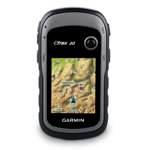
However, regular users of this model distinguish the following disadvantages:
- not very convenient to use for left-handed people, since the control joystick is in the upper right corner;
- high price;
- poor Russification.
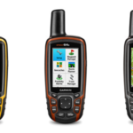
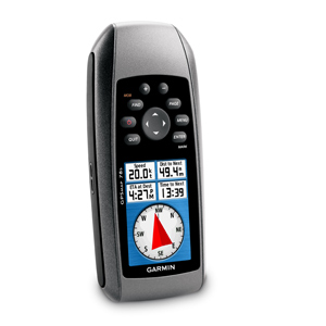
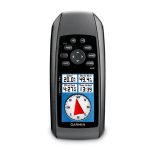
If you are a lover of the water element, then the “floating” model of the garmin 78s navigator will be an ideal acquisition for you. Its main feature, as can be clearly seen from the description, is that when it enters the water it does not sink, but remains to float on the surface. Which is very popular, for example, on fishing. For the same purpose, the side handles of the GPS receiver are made of rubber. Otherwise, its functions largely coincide with the previous model.
Cartography Update
For the navigator to perform its basic functions well, it is necessary that the information it uses is up to date. Therefore, you should periodically check for updates to your data. To simplify this process, Garmin has developed a special MapChecker program for users of its products. After installation, the application will independently check for new cards and, if detected, will tell you the address where you can download updated versions.
 |  |  |  |  |
|
| Title | Garmin DriveLuxe 50 RUS LMT | Garmin eTrex 20x | Garmin GPSMAP 64 | Garmin GPSMAP 78S | Garmin eTrex 10 |
| Screen diagonal | 5 in. | 2.2 in. | 2.6 in. | 2.6 in. | 2.2 in. |
| Screen resolution | 800x480 pixels | 240x320 px | 160x240 px | 160x240 px | 128x240 pixels |
| Connection | USB, Bluetooth | USB | USB | USB | USB |
| Equipment | Comes complete with maps of Russia; car power cable, magnetic car mount, USB cable, quick start guide | pre-installed map "Roads of Russia. RF. TOPO", USB-cable, documentation | lanyard for mounting, USB cable, user manual | navigator, USB cable, user manual | navigator, USB cable, user manual |
| Price | from 23800 rub. | from 11990 rub. | from 18500 rub. | from 22600 rub. | from 8000 rub. |